Ralf Bokermann
Skizze zu Kleinstädten im unteren Oderraum und südlichen Vorpommern
Online - Arbeit 1/ 2014
1. Kleinstädte in Randlagen
In den letzten Jahren ist die Bedeutung von Kleinstädten für den ländlichen Raum ein Thema für Untersuchungen, Tagungen und Arbeiten verschiedener Art gewesen. Mit weitgehender Übereinstimmung wurde heraus gearbeitet, dass Kleinstädte als Netz zentraler Orte die Struktur des ländlichen Raumes prägen. Die Bandbreite der hier angesiedelten Funktionen geht über nahezu alle Lebens- und Arbeitsbereiche. Kleinstädte sind Standorte für Schulen, Einkauf, örtliche und regionale Verwaltung, medizinische Versorgung, Kultur- und Unterhaltungsangebote und nicht zuletzt Zentren für Beschäftigung und Wertschöpfung im ländlichen Raum.
Weniger nachgegangen wurde bisher der Frage, welche Bedeutung die Kleinstädte in unterschiedlichen ländlichen Regionen haben. Frühere eigene Erhebungen lassen den Schluss zu, dass die Funktionen der Kleinstädte für das Umland umso wichtiger werden, je dünner die jeweiligen Regionen besiedelt und je ausgeprägter die periphere Lage ist. Je weiter die nächste Metropolregion entfernt und somit schwieriger erreichbar ist, umso wichtiger werden für die Bewohner die Funktionen der kleineren Zentren.
In Deutschland trifft eine periphere Lage relativ eindeutig für den Raum an der östlichen Landesgrenze entlang der unteren Oder und des Stettiner Haffs zu. Eine Bestätigung der These über eine herausgehobene Funktion der dortigen Kleinstädte wäre an eingehende Erhebungen vor Ort und deren Auswertung gebunden. Bisher waren jedoch nur kurze Vorerhebungen über allgemeine regionale Gegebenheiten und sichtbare städtebauliche Aspekte möglich. Diese werden in Form einer Skizze zusammengefasst. Aufgrund der nur skizzenhaften Basis unterbleiben Urteile und Wertungen weitgehend.
2. Regionale Gegebenheiten
Das zu skizzierende Gebiet erstreckt sich vom südlichen Landkreis Uckermark (Land Brandenburg) bis zur Mitte der Region Vorpommern südlich von Greifswald, umfasst hier also weitgehend den neu gebildeten Landkreis Vorpommern-Greifswald. Geografisch bildet der Raum insofern eine Einheit, als er im Jungmoränengebiet der letzten Eiszeit (Weichseleiszeit, Abklingen vor ca. 12 000Jahren) liegt, das nur im Nordosten Deutschlands vertreten ist. Gegliedert wird die Landschaft in meistens höher gelegene Grundmoränen- und Sanderplatten, und mehrere, teilweise breite Flussniederungen. Überwiegend ackerbaulich genutzt werden die Grundmoränen und teilweise auch die Sanderflächen. Die Flusstäler sind überwiegend Grünland. Namhafte Flusstäler sind im südlichen Raum die von Welse, Randow und Uecker, im nördlichen Teil die von Zarow, Peene und Ziese. Durch ein planmäßiges Gewässernetz sind die meisten Flussniederungen intern gegliedert.
Für den überregionalen Verkehr ist die Region relativ gut erreichbar. Von Berlin kommend führt die Autobahn 11 bis südlich von Stettin über die Grenze nach Polen. Die Autobahn 20 erschließt ab der nördlichen Uckermark den weiteren Küstenraum der Ostsee und verbindet diesen mit dem norddeutschen Autobahnnetz. Wichtigste Bahnverbindung ist die von Berlin nach Stralsund.
Amtliche Aussagen zur Raumplanung weisen den skizzierten Raum im gesamtdeutschen Vergleich als dünn besiedelt und peripher gelegen aus, mit unter dem Durchschnitt liegenden regionalwirtschaftlichen Entwicklungsstand. Hoch anzusetzen ist dagegen das Potential für die Landwirtschaft, die Attraktivität der Landschaft und insbesondere für den Tourismus. – Angaben über die gegenwärtige Zahl der Einwohner geben den Stand Ende 2012 wieder.
3. Skizzierung von ausgewählten Kleinstädten
3.1 Gemeinsame Merkmale
Kurz skizziert werden die 6 bedeutendsten Kleinstädte des Gebiets, die überwiegend mehr als 10 Tsd. Einwohner haben und erkennbar wichtige Funktionen für das weitere Umland haben. Vor den Verwaltungsreformen nach 1990 waren die Städte Sitz der Kreisverwaltung, für damals deutlich kleinere Landkreise. – Für die gesamte Region gilt, dass sie in den letzten Wochen des 2. Weltkriegs Frontgebiet war und die historischen Kerne von 50% der dargestellten Kleinstädte weitgehend zerstört wurden. Der Wiederaufbau erfolgte offenbar mit wesentlichen Anteilen durch mehrgeschossige Wohnblocks, die bis an die historischen Kerne, wie Marktplätze und Stadtkirchen, heranreichen. Der Verlust an historischer Baukultur ist dadurch relativ auffällig. Erhalten sind in allen Kleinstädten die mittelalterlichen Kirchen, überwiegend im Stil der Backsteingotik, die in einigen Kleinstädten der Größe nach Kathedralen ähnlich sind. Die Kirchenbauten sind ein Beleg für den wirtschaftlich bedeutenden Stand dieser Kleinstädte sowie der Region im Mittelalter. In der Gegenwart ist die bauliche Sicherung und Behebung noch vorhandener Kriegsschäden ein offenbar dauerhaft wirtschaftliches Problem für die Erhaltung der Kirchen.
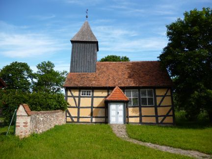
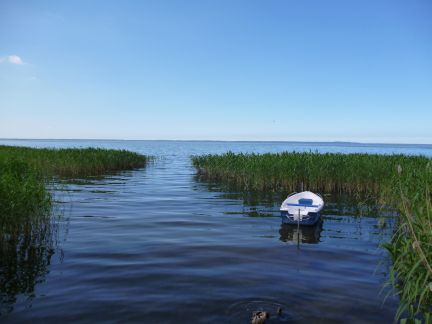
Abb. 1: Fachwerkkirche in Abb. 2: Schilfgürtel am Stettiner
Breest, 25 km westlich von Anklam. Haff östlich von Ueckermünde.
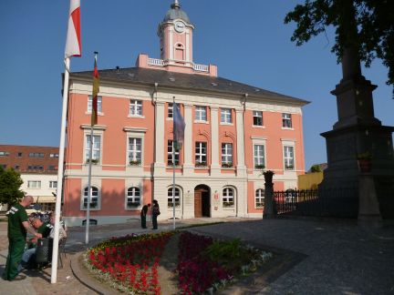
3.2 Angermünde
Die Kleinstadt liegt im Südosten des Landkreises Uckermark am Mündesee. Das Umland ist ein flachwelliges Endmoränengebiet mit überwiegend sandigen, für den Ackerbau mittleren bis weniger guten Böden. Im Stadtgebiet sind 13,7 Tsd. Einwohner ansässig. Mit 23 Ortsteilen hat Angermünde eine erhebliche Flächengröße. Im Westen und Süden liegt das Stadtgebiet im Biosphärenreservat Schorfheide- Chorin, der östliche Teil im Nationalpark „Unteres Odertal“.
Die Innenstadt mit einem sehenswerten Baubestand und einem wesentlichen Teil der Stadtmauer ist unzerstört erhalten. Ab 1991 wurde die historische Altstadt schrittweise saniert und wurde dafür mehrfach ausgezeichnet. Seit 1994 ist die Altstadt als Bodendenkmal ausgewiesen. – Das Verzeichnis der wirtschaftlichen Unternehmen weist vor allem kleine und mittlere Betriebe vieler Gewerbesparten auf. Ein größeres Gewerbegebiet soll weitere Ansiedlungen erleichtern. Das touristische Angebot gründet sich vor allem auf die Vorzüge der Landschaft, die beste Voraussetzungen für Wasser- und Radsportarten bietet.
Abb. 3: Angermünde - Markt- Abb. 4: Erhaltene Stadtmauer mit
platz mit Rathaus. Turm in Angermünde.
.3 Prenzlau
Prenzlau ist Hauptort der historischen Landschaft Uckermark und Kreisstadt dieses flächenmäßig großen Landkreises. Die Stadt liegt im Tal der Ucker und grenzt im Süden an den Oberuckersee. Vor allem östlich und nördlich erstrecken sich Landschaften auf Grundmoränen mit überwiegend guten Böden und vorherrschender Ackernutzung. Im Südwesten grenzt das Stadtgebiet an den Naturpark „Uckermärkische Seen“. Die Gemeinde zählt mit 19,0 Tsd. Einwohnern und 8 Ortsteilen zu den größeren Kleinstädten.
Im 2. Weltkrieg wurden über 80% des Stadtkernes zerstört. Das innere Stadtbild wird heute von Wohnblocks geprägt, aber auch von noch vorhandenen historischen Bauten. Zu nennen sind vor allem die Marienkirche, ein Dominikanerkloster sowie die etwa noch zur Hälfte erhaltene Stadtmauer mit einem herausragenden Torturm. Prenzlau hat seit 1991 fast flächendeckend an den Programmen der Städtebauförderung teilgenommen, u.a. wurde das Stadtviertel Sternberg mit historischer Bebauung wieder hergestellt.
Die Stadt verfügt über eine recht gute Verkehrsanbindung. In der Stadt kreuzen sich mehrere Bahnlinien, am wichtigsten dürfte die ICE-Strecke von Berlin nach Stralsund sein. Für die Autobahn 20 gibt es zwei stadtnahe Auffahrten, für die A11 einen Anschluss in nicht allzu großer Entfernung. – Mehrere gut besetzte Gewerbegebiete lassen eine relativ starke wirtschaftliche Basis erkennen. Vom Stadtgebiet gehen ferner viele touristische Angebote aus. Im Vordergrund stehen Wasser- und Angelsport. Durch Prenzlau führt der Fernradweg von Berlin nach Usedom.

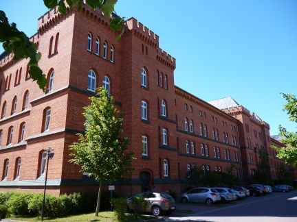
Abb. 5: Umgenutzte Wirtschaftsge- Abb. 6: Hauptgebäude des
bäude der ehemaligen Domäne ehemaligen Kasernenkomplexes .
Ferdinandshof bei Pasewalk. in Pasewalk.
3.4 Pasewalk
Die Stadt liegt am Fluss Uecker, ganz im Süden des Landkreises Vorpommern-Greifswald. Beiderseits der Stadt liegen flachwellige, vereinzelt kuppige Platten der Grundmoräne mit relativ guten, überwiegend durch Ackerbau genutzten Böden. Nordöstlich schließt sich die Ueckerniederung und daran das Flachland der Ueckermünder Heide bis zum Stettiner Haff an. – Die Stadt hat 10,6 Tsd. Einwohner. Bis 2011 war Pasewalk Kreisstadt des Uecker-Randow-Kreises. Erhalten ist die Funktion als Verwaltungssitz von 15 Gemeinden bzw. Ortsteilen im Umland.
Die Innenstadt wurde im 2. Weltkrieg weitgehend zerstört. Der Wiederaufbau erfolgte auch hier über Wohnblocks, die an den zentralen Marktplatz heranreichen. Erhalten ist u.a. der Backsteinbau der Sankt-Marien-Kirche, nennenswerte Teile der mittelalterlichen Stadtbefestigung mit 2 Tortürmen sowie das große, mit Backstein errichtete Hauptgebäude des ehemals bedeutenden preußischen Kasernenkomplexes. Mit Hilfe der Städtebauförderung wurden die Innenstadt und andere Stadtareale seit 1991 saniert.
Pasewalk liegt in geringer Entfernung zur Autobahn 20 und – wie Prenzlau – an der Hauptbahnlinie von Berlin nach Stralsund. Gekreuzt wird die Stadt ferner von einer Bahnlinie, die von Stettin über Lübeck nach Hamburg führt. – Informationen über die örtliche Wirtschaft weisen auf Betriebe der Lebensmittel- und Baustoffindustrie sowie auf solche des Elektro- und Metallhandwerks hin. Trotz der Entfernung von ca. 130 km nach Berlin dürften handwerkliche Betriebe dort Arbeit finden.
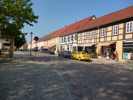
3.5 Ueckermünde
Ueckermünde ist mit 8,94 Tsd. Einwohnern und 4 Ortsteilen ausgewiesenes Mittelzentrum der Planungsregion. Die Stadt liegt etwa 2 km entfernt von der Mündung der Uecker in das Stettiner Haff und damit in die Ostsee. Nach Norden mündet in geringer Entfernung der Fluss Zarow in das Haff. Über das gesamte Hinterland erstrecken sich auf etwa 50 km die ebenen Sanderflächen der Ueckermünder Heide.
Abb. 7: Straßenbild der Abb. 8: Strandbad von Ueckermünde
Hafenstadt Ueckermünde. am Stettiner Haff.
Die Stadt ist im Weltkrieg unzerstört geblieben und verfügt über einen historischen Stadtkern. Das erhaltene Stadtbild und viele sehenswerte Bauten veranschaulichen, welchen Verlust an historischer Baukultur die Region durch die Kriegsschäden in anderen Städten erlitten hat. Seit 1991 wurden der Stadtkern sowie Wohnblock-Siedlungen über die Städtebauförderung saniert. Restauriert wurde auch der Südflügel des auf das Jahr 1546 datierten Herzogschlosses.
Im wirtschaftlichen Bereich ist u.a. die Chemieindustrie und Holzverarbeitung vertreten. Der vorhandene Industriehafen kann auch von größeren Frachtern angelaufen werden. Nach außen geprägt wird die Stadt nicht zuletzt durch den Tourismus. Ueckermünde ist anerkanntes Seebad. Ein großes Strandbad sowie ein Yachthafen werden diesem Anspruch gerecht.
3.6 Anklam
Die ehemalige Hansestadt liegt oberhalb der hier breiten Flussniederung der Peene, etwa 7 km von der Mündung des Flusses in das Stettiner Haff entfernt. Nahe der Mündung führt eine Straßenbrücke über den Peenestrom (westlicher Abfluss des Haffs in die Ostsee) auf die Insel Usedom. Im Umland von Anklam herrschen auf Sanderflächen Böden geringerer bis mittlerer Qualität vor, mit überwiegender Ackernutzung.
Abb. 9: Marktplatz von Anklam Abb. 10: Blick vom Marktplatz auf
mit Blick auf die Kirche St. Nikolai. erhaltenen Torturm in Anklam.
Anklam ist ehemalige Kreisstadt und hat gegenwärtig 12,9 Tsd. Einwohner. Nach 1990 fand eine starke Abwanderung statt (im Jahr 1988: 19,7 Tsd. Einwohner). Die historische Innenstadt wurde durch Bombenangriffe und während der letzten Kriegswochen stark zerstört. Nach 1991 wurde mit Hilfe differenzierter Förderprogramme das Stadtzentrum saniert. Der Marktplatzt mit angrenzenden Gebäuden wurde rekonstruiert. Erhalten ist die imposante Marienkirche. Für die überwiegend wieder hergestellte Nikolaikirche sind zusätzliche bauliche Sicherungen vorgesehen. Weitere erhaltene Bauwerke sind ein gotisches Giebelhaus, ein Tor-Wehrturm mit dort eingerichtetem Museum sowie eine erneuerte Hä userzeile, die einen Eindruck der alten Baukultur vermittelt. Gesichert wurden auch Teile der Stadtmauer. Anklam liegt an der Europäischen Route der Backsteingotik.
Durch das Stadtgebiet führen mehrere Bundesstraßen. Der Anschluss an die Autobahn 20 befindet sich ca. 25 km westlich. Wie die meisten Kleinstädte der Region ist auch Anklam Station der Bahnlinie von Berlin nach Stralsund. – Bis zum Binnenhafen der Stadt ist die Peene schiffbar, eine vor allem im Mittelalter wichtige Verbindung zur Ostsee. Eine weitere, wichtige Anbindung ist der für den allgemeinen Flugverkehr zugelassene Flugplatz.
Wirtschaftlich stützt sich Anklam auf eine Mischung von kleinen und mittleren Unternehmen verschiedener Sparten. Nennenswerten Umfang haben die touristischen Angebote. Diese machen deutlich, dass die Nähe zur Insel Usedom genutzt wird.
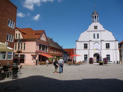
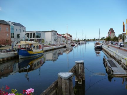
Abb. 11: Rathaus am Marktplatz Abb. 12: Häuserzeile am Hafen
in Wolgast. von Wolgast.
3.7 Wolgast
Die ehemalige Hansestadt liegt unmittelbar am Peenestrom, über den hier die zweite (nördliche) Brücke zur Insel Usedom führt. Das Umland ist ein Sandergebiet mit meistens weniger guten, aber dennoch ackerbaulich genutzten Böden. Südwestlich erstreckt sich ein lang gezogener, häufig bewaldeter Endmoränenzug. – Wolgast hat 12,5 Tsd. Einwohner in 11 Ortsteilen und ist ausgewiesenes Mittelzentrum des Landes.
Die Innenstadt ist gut erhalten mit einem sehenswerten Stadtbild und ebensolchen Einzelbauten. Seit 1991 wurden der Stadtkern und weitere Siedlungsareale schrittweise über die Städtebauförderung saniert. Hervorzuheben sind die Petrikirche – eine dreischiffige Basilika -, das historische Rathaus sowie erneuerte Teile der Stadtmauer. Wolgast ist Standort der Europäischen Route der Backsteingotik.
Ein wirtschaftliches Standbein der Stadt ist die Peenewerft mit Zulieferbetrieben. Nicht zu übersehen ist ein breites Tourismus-Angebot. Neben Schiffs- und Bootsrouten können Radsportfahrten verschiedener Art genutzt werden. Zum weiteren Angebot zählt ein Tierpark.
3.8 Exkurs: Templin
Templin liegt in der westlichen Uckermark und damit außerhalb der vorab abgegrenzten Region entlang der Oder. Ein Grund, auf die Stadt einzugehen, ist die erhaltene Innenstadt, die neben Angermünde ein Studium der baulichen Anlage von Kleinstädten im nordöstlichen Brandenburg erlaubt. Das Umland liegt auf einer Sanderplatte mit größeren geschlossenen Waldgebieten. Die Stadt grenzt an den Templiner See sowie an den Naturpark „Uckermärkische Seen“. Südöstlich schließt sich das Biosphärenreservat Schorfheide- Chorin an.
Templin hat 16,1 Tsd. Einwohner. Die zugeordneten 24 Ortsteile sind teilweise von der Größe her Weiler. Mit der Innenstadt ist die gut restaurierte Stadtmauer mit mehreren Tortürmen und Wiekhäusern beinahe vollständig erhalten. – Eine direkte Verkehrsanbindung an das Berliner Umland (ca. 80 km entfernt), an Prenzlau und weiter nach Norden besteht über die Bundesstraße 109. Weiterhin besteht Bahnanschluss und ca. 25 km östlich Zugang zur Autobahn 11.
Templin ist ebenfalls ausgewiesenes Mittelzentrum. An Gewerben sind auch hier Klein-und Mittelbetriebe vieler Sparten vertreten. In eigenen Darstellungen setzt die Stadt stark auf den Tourismus, wobei auf die relative Nähe zu Berlin verwiesen wird. Templin ist Thermalsole-Heilbad. Die Nähe zu zahlreichen Seen formt das weitere Angebot.
Abb. 13: Rathaus von Templin Abb. 14: Zum Marktplatz führende
am Marktplatz. Häuserzeile in Templin.
4. Literatur (Auswahl)
1. Amt f. Statistik Berlin- Brandenburg, 2013: Bevölkerung im Land Brandenburg nach amtsfreien Gemeinden, Ämtern u. Gemeinden. Internetdatei, Potsdam.
2. Bokermann, R., 2009: Kleinstädte in ländlichen Räumen. Ecovast- Schriftenreihe, Bd.7. Hrsg. Ecovast, Eckernförde.
3. Bundesamt f. Bauwesen u. Raumordnung, 2005: Raumordnungsbericht 2005. Berichte, Bd. 21, Bonn.
4. Eckart, K. (Hrsg.), 2001: Deutschland. Perthes Länderprofile. Verlag J. Perthes, Gotha.
5.Glaser, R. et al., 2007: Geographie Deutschlands. Wiss. Buchgesellschaft, Darmstadt.
6. Künzel, W. / W. Rellecke (Hrsg.), 2008: Geschichte der Deutschen Länder. Aschendorf Verlag, Münster.
7. Liedke, H. u. J. Marcinek (Hrsg.), 2002: Physische Geographie Deutschlands. Verlag J. Perthes, Gotha.
8. Ministerium f. Infrastruktur u. Landwirtschaft (Hrsg.), 2009: Landes-entwicklungsplan Berlin- Brandenburg. Potsdam.
9. Regionaler Planungsverband Vorpommern, 2010: Regionales Raument-wicklungsprogramm Vorpommern. Internetdatei, Greifswald.
10. Statistisches Landesamt Mecklenburg- Vorpommern, 2013: Bevölkerungs-entwicklung der Kreise u. Gemeinden. Internetdatei, Schwerin.
11. Weiß, W. (Hrsg.), 1996: Mecklenburg- Vorpommern. Perthes Länderprofile. Verlag J. Perthes, Gotha.
12. Verlag G. Westermann, 2005: Deutschland in Karten/ Diercke Atlas. Braunschweig.
13. Weitere Quellen: Offizielle Internetseiten der unter Ziff. 3.2 bis Ziff. 3.8 angeführten Kleinstädte.
Ralf Bokermann
Study on Small Towns in the Lower Oder area and
West-Pomerania
1. Small towns in peripheral regions
Over the last few years the significance of small towns for the rural area has been a topic for research, conferences and various papers. A far-reaching agreement was worked out that small towns, as a focus network, shape the structure of the rural area. The range of functions established here goes beyond almost all spheres of life and fields of work. Small towns are locations for schools, purchasing, local and regional administration, medical supply, culture and offers of entertainment and not least centres of employment and creation of added value in rural spaces.
The significance of small towns in various rural regions has as yet not be pursued that much. Earlier own surveys give rise to the conclusion, that functions of small towns are the more important to the surrounding area, the more sparsely the current regions are populated and the more distinctive the peripheral situation is. The further the next metropolitan region is and therefore more difficult to reach, the more important the functions of the smaller centres become for the residents.
A peripheral situation applies quite obviously to the area in Germany along the eastern national border along the lower Oder and the Stettiner Haff (Haff = lagoon). A confirmation of the theory of an increased function of the small towns there would be bound to surveys on the spot and their evaluation. However up to now, only short surveys have been possible on general regional conditions and visible urban development aspects. These are summarised as an outline. Due to the roughly sketched basis, judgements and valuations remain largely incomplete.
2. Regional conditions
The area to be outlined extends from the southern administrative district Uckermark (Federal State of Brandenburg) up to the centre of the region West-Pomerania, south of Greifswald, and encompasses more or less the newly created administrative district of Pomerania-Greifswald. The area in this respect geographically forms a unit as it is situated in the young moraine area of the last glacial period (Weichselian glacial period, wear off approx. 12,000 years ago), which is represented only in the northeast of Germany. The landscape is divided into subglacial till and sandar slabs and several, partly broad river plains. The ground moraines and partly the sandar areas as well are mainly used for agriculture. The river valleys are mainly grassland. Well-known river valleys in the southern area are Welse, Randow and Uecker, in the northern area Zarow, Peene and Ziese. Most river plains are internally segmented via a systematic drainage network.
For the transregional traffic, the region is relatively well accessible. Coming from the direction of Berlin, the Motorway 11 goes to south of Stettin over the border to Poland. The Motorway 20 from the northern Uckermark makes the coastal area of the Baltic Sea accessible and connects up with the North German network of motorways. The most important train connection is the railway line from Berlin to Stralsund.
Official statements concerning regional development report the outlined area as sparsely populated and peripheral in an all-German comparison, and the regional economic development as below average. The potential for agriculture, the countryside appeal and particularly for tourism are estimated as being high.
3. Outline of selected small towns
3.1 Common features
The 6 most important small towns of the area which have more than 10,000 inhabitants are outlined and are predominantly more important for the surrounding countryside. Before the administrative reforms after 1990, the towns were seat of district government for considerably smaller administrative districts at that time. During the last weeks of the 2nd World War this was a front line area and in this time 50% of the small towns were largely destroyed. The reconstruction was mainly realized by multi-storeyed apartment blocks, built up to the historical areas like market places and churches. The loss of an historical building culture is very noticeable by this. The medieval brick Gothic churches, predominant in some small towns often have the size of cathedrals. These church buildings are evidence for the economically important stand of these small towns and the region in the Middle Ages. The prevailing war-damaged structures show the economic problem for the preservation of the churches.
Fig. 1: Church in Framework Fig. 2: Reed belt at the
style, 25 km west Stettiner Haff east of
of Anklam . Ueckermünde
3.2 Angermünde
The small town is located southeast of the administrative district Uckermark at the Münde Lake. The surrounding countryside is predominantly a light wavy moraine area, mainly sandy, for agriculture medium to less fertile soils. There are 13,700 inhabitants in the town area. With 23 surrounding villages Angermünde has a considerable size. The municipal area is located in the west and south in the biosphere reserve Schorfheide-Chorin, the eastern part in the national park "Lower Oder Valley".
The town centre with a remarkable building stock and an essential part of the city wall has been preserved. From 1991 the historical old town was gradually re-established and has been rewarded for this. The old part of the town has been classed as an earth heritage since 1994. - The listing of the economic enterprises shows primarily small and medium-sized enterprises of various trade sectors. A larger industrial estate will facilitate larger settlements. The touristic offer is mainly based on the advantages of the landscape which provides best prerequisites for water and cycling sports.
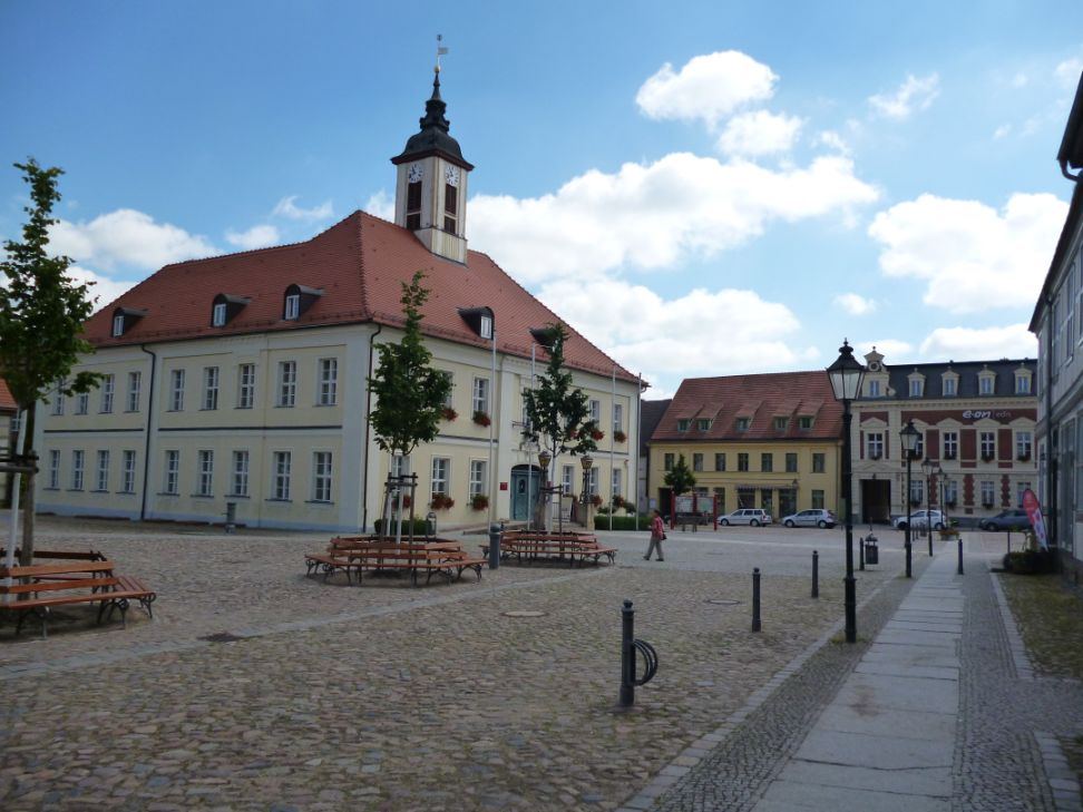
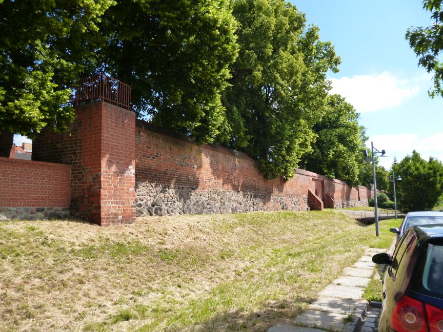
Fig. 3: Marked place Fig. 4: Preserved town
with city hall in wall with tower in
Angermünde. Angermünde.
3.3 Prenzlau
Prenzlau is the main town within the historical landscape of Uckermark and is the district capital of this large administrative district. The town is located in the valley of the Ucker and borders on the Oberucker Lake in the south. Mainly to the east and north landscapes are on subglacial till with predominantly good soils and mainly farmland. The municipal area borders on the national park "Uckermärkische Seen" in the southwest. The municipality with 19,000 inhabitants and 8 assigned villages count as one of the larger townships.
In the 2nd World War more than 80% of the town centre was destroyed. The inner urban area is characterised by apartment blocks but also by historical buildings. St. Mary's church, a Dominican monastery as well as half of the city wall with an outstanding gate tower still remain. Since 1991 Prenzlau has taken part almost consistently within the urban development supporting programs, including the town district of Sternberg being restored with historical buildings.
The town has quite good traffic links. Several railroad lines cross in the town, the most important one being the Intercity Express route from Berlin to Stralsund. There are two access roads for the Motorway 20, for the Motorway 11 a connection not too far away. Due to several busy industrial estates, a relatively strong economic base can be seen. Furthermore many tourist offers can be seen from the town area, mainly water sports and fishing. The cycling track from Berlin to Usedom runs through Prenzlau.
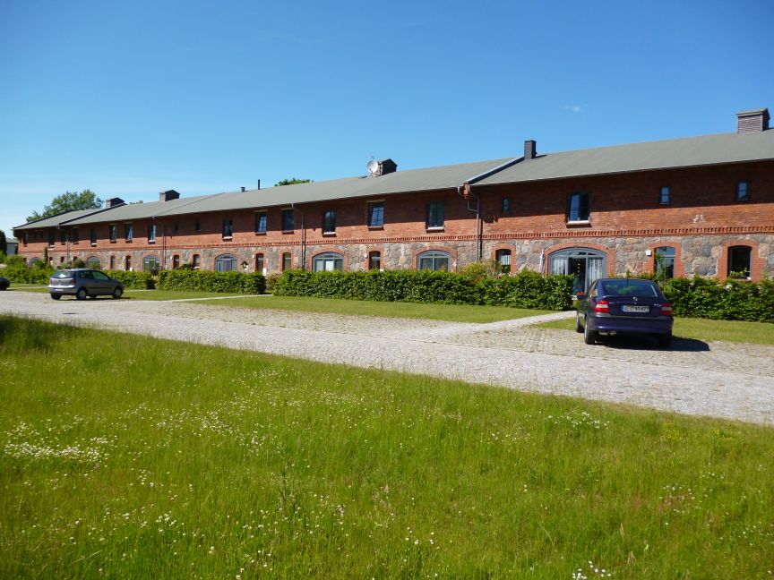
Fig. 5: For residences Fig. 6: The main building
redesigned farm buildings of former barracks
on the Domain of complex in Pasewalk.
Ferdinandshof near
Pasewalk.
3.4 Pasewalk
The town is located on the river Uecker, in the south of the district West-Pomerania-Greifswald. On both sides of the town there are low wavy, occasional knobby slabs of ground moraine with soils which are relatively good and used predominantly in agriculture. In the north-east the Uecker lowland closes and then the lowland of the Ueckermünder heath up to the Stettiner Haff in the northeast. The town has 10,600 inhabitants. Pasewalk was the district capital of the Uecker-Randow district up to 2011. It still functions as administrative centre of 15 connected villages in the surrounding countryside.
The town centre was destroyed in the 2nd World War for the most part. The reconstruction was carried out by building apartment blocks up to the market square. The brick-built Saint Mary’s church, considerable parts of the medieval town wall with two gate towers as well as the main building of the large, brick-built Prussian barracks complex have all been preserved. With the help of the urban development support programs the centre and other town areas have been repaired since 1991.
Pasewalk is near Motorway 20 and - as Prenzlau - near the main rail line from Berlin to Stralsund. Furthermore the town is crossed by the railroad line to Hamburg from Stettin via Lübeck. Informations on the local business world shows the electrical and metal trades to food and building-material producers. Despite the distance of approx. 130 km to Berlin, craftsmen should still be able to find work there.
3.5 Ueckermünde
Ueckermünde with 8,940 inhabitants and 4 assigned villages in its hinterland is a medium centre of the state regional planning. The town is located about 2 km away from the estuary of the Uecker into the Stettiner Haff and thus into the Baltic Sea. In the north the river Zarow runs into the lagoon. The flat sandar areas of the Ueckermünder heath are extended over the complete hinterland of about 50 km.
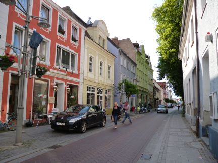
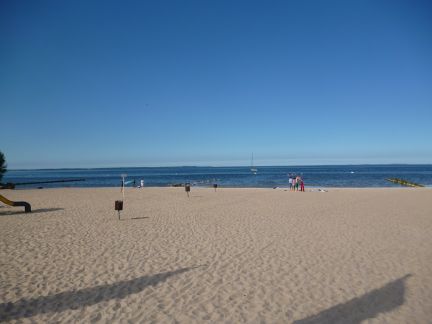
Fig. 7: Street line in the Fig. 8: Swimming area of
seaport Ueckermünde. Ueckermünde at the
Stettiner Haff.
The town remained intact in the World War and has an historical town centre. The preserved urban features and many remarkable buildings illustrate which loss other towns in the region have suffered with war-damaged historical buildings. Since 1991 the town centre and apartment blocks have been repaired through urban development support programs. The south wing of the duke’ s castle dated 1546 has also been restored.
The chemical and wood-processing industries and others are present in this region. The industrial docks can also be called at by larger freighters. The town is characterised by tourism. Ueckermünde is a recognised seaside resort. A large bathing beach as well as a marina does justice to this claim.
3.6 Anklam
The former Hanseatic town is situated above the Peene river plain, about 7 km from the river estuary into the Stettiner Haff. A road-bridge runs over the Peene river (western outlet of the lagoon into the Baltic Sea) near the estuary to the island of Usedom. In Anklam's surrounding countryside glacial outwash soils of poorer to medium quality predominate with mainly arable use.
Anklam is a former district capital and has at present 12,900 inhabitants. After 1990 intense migration took place (in 1988 there were 19,700 inhabitants). The historical centre was heavily destroyed by bomb raids and during the last weeks of the war. After 1991 the town centre was redeveloped with the help of various promotional programmes. The market square with adjacent buildings was reconstructed. The stately St. Mary's church was preserved. There has been additional reconstruction work done on the Nikolai church. Further preserved buildings are a Gothic gabled house, a fortified tower gate with a museum set up there as well as a row of houses which conveys an impression of the old building culture. Parts of the city wall were also secured. Anklam is situated on the European route of red-brick Gothic architecture.
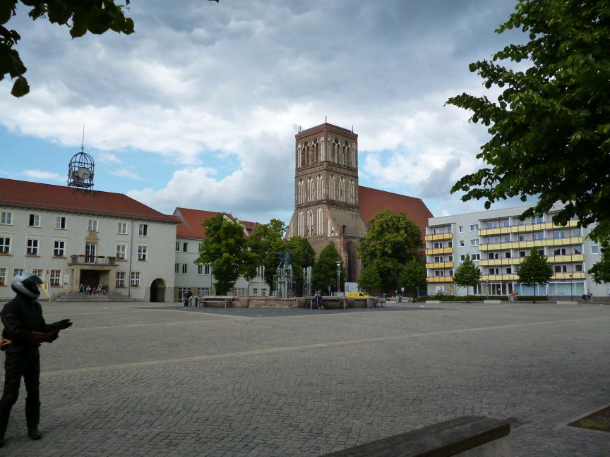
Fig. 9: Anklam' s market Fig. 10: View of the market
square with view of square to restored gate.
St Nicolai church. tower in Anklam.
Several federal roads run through the municipal area. The junction to the Motorway 20 is approx. 25 km to the west. Like most small towns of the region Anklam has a railway station on the railroad line from Berlin to Stralsund. The river Peene is navigable up to the inland port of the town. This was an important route in the Middle Ages to the Baltic Sea. Another important connection is the authorised airfield for general air traffic.
Anklam is supported economically on a mixture of small and medium-sized enterprises of different branches. Offers from tourism are considerable. These show that the proximity to the island of Usedom is beneficial.
3.7 Wolgast
The former Hanseatic town lies directly on the Peene river where the second (northern) bridge leads to the island of Usedom. The surrounding countryside is a glacial area with soils which are mostly not so good but nevertheless used for arable farmland. In the south west there is a long terminal moraine which is frequently wooded. Wolgast has 12,500 inhabitants with 11 assigned villages and is designated as a medium centre of the state.
Fig.11: Town hall on the Fig. 12: House row at the
market square of Wolgast. port of Wolgast.
The centre is well preserved with remarkable urban features. Since 1991 the town centre and wider settlement areas were gradually reconstructed with help from the urban development programs. Emphasis should be put on the Petri church – a three knaved basilica - the historical town hall as well as parts of the town wall. Wolgast is a site on the European route of the red-brick Gothic architecture.
An economic pillar of the town is the Peene shipyard with suppliers. Not to be overseen are the many touristic offers. Apart from ship and boating routes, various cycling trips are on offer. A further attraction is the zoo.
3.8 Excursus: Templin
Templin is situated in the western Uckermark and so outside of the deferred region along the Oder. Interesting is the preserved town centre which besides Angermünde allows the studies of the structure of small towns in the north eastern area of Brandenburg. The surrounding countryside is located on a glacial slab with larger closed woodlands. The town borders on the Templin Lake and on the national park "Uckermärkische Seen". The biosphere reserve Schorfheide-Chorin is aligned to the southeast.
Fig. 13: Town hall of Fig. 14: Row of houses
Templin. leading to the market
square of Templin.
Templin has 16,100 inhabitants. The assigned 24 villages are partly the size of hamlets. Together with the town centre the town wall with several gate towers and Wiek houses (small houses within the town wall) is well restored. There is a direct traffic connection to Berlin’s surrounding countryside, to Prenzlau and further to the north via the federal road 109. Furthermore there are train connections, and to the east access in approx. 25 km to the Motorway 11.
Templin is medium centre too. Small and medium-sized industries of many divisions are represented here too. The town backs tourism in which the relative proximity to Berlin is referred to. Templin is a thermal saline medicinal spa. The proximity to numerous lakes is also important for tourism.
4. Literature (Choice)
1. Office f. statistics Berlin- Brandenburg, 2013: Population in the Federal State of Brandenburg to district independent communities and communities. Internet data set, Potsdam.
2. Bokermann, R., 2009: Small towns in rural regions. Ecovast document line, 7th ed. Pub. Ecovast, Eckernförde.
3. BBR – Federal Office f. structure affairs and space science, 2005: Space planning report 2005. Reports, vol. 21, Bonn.
4. Eckart, K. (ed.), 2001: Germany. Perthe’s country profiles. Pub. house J. Perthes, Gotha.
5. Glaser, R. et al., 2007: Geography of Germany. Science Book Society, Darmstadt.
6. Künzel, W. / W. Rellecke (ed.), 2008: History of the German states. Aschendorf pub. house, Münster.
7. Liedke, H. and J. Marcinek (ed.), 2002: Physical Geography of Germany. Pub. house J. Perthes, Gotha.
8. Ministry f. infrastructure and agriculture (ed.), 2009: State development plan Berlin- Brandenburg. Potsdam.
9. Regional planning association West- Pomerania, 2010: Regional space development program of West- Pomerania. Internet data set, Greifswald.
10. Statistical state office of Mecklenburg / West- Pomerania, 2013: Development of Population in districts and communities. Internet data set, Schwerin.
11. Weiss, W. (ed.), 1996: Mecklenburg / West- Pomerania. Perthe’s country profiles. Pub. house J. Perthes, Gotha.
12. Pub. house G. Westermann, 2005: Germany in maps / Diercke Atlas. Braunschweig.
13. Other scources: Official internet data sets of the on number 3.2 to 3.8 listed small towns.